Storm Erin path has captivated weather watchers and coastal residents alike as this powerful storm carves its way through the Atlantic. As the fifth named storm of the 2025 Atlantic hurricane season, Erin has already made headlines by rapidly intensifying into a major hurricane. But where is it headed? Will it slam into the U.S. East Coast, or will it veer harmlessly out to sea? Let’s dive into the details of Storm Erin’s path, its impacts, and what you need to know to stay safe and informed.
What Is Storm Erin and Why Does Its Path Matter?
Imagine a spinning giant in the Atlantic, gathering strength from warm ocean waters like a sprinter fueling up for a marathon. That’s Storm Erin—a tropical system that formed on August 11, 2025, and quickly escalated from a tropical storm to a Category 5 hurricane before settling as a Category 4 by August 16. The path of Storm Erin is critical because it determines which regions face heavy rain, dangerous surf, or life-threatening rip currents. For coastal communities, understanding this path is like having a roadmap to prepare for what’s coming.
Erin’s journey began east of the Caribbean, and its trajectory has kept meteorologists on their toes. With maximum sustained winds reaching 150 mph at its peak, this storm isn’t just a blip on the radar—it’s a force of nature demanding attention. So, what makes tracking the Storm Erin path so essential? It’s about giving people the chance to brace for impact, whether that’s stocking up on supplies or steering clear of treacherous beaches.
The Evolution of Storm Erin Path: From Formation to Forecast
How Storm Erin Formed
Every hurricane starts as a spark, and for Storm Erin, that spark ignited over the warm waters of the eastern Atlantic. On August 11, 2025, a tropical wave morphed into a tropical depression, then rapidly strengthened into Tropical Storm Erin. By August 15, it was a hurricane, and by the next day, it hit Category 5 status with winds of 160 mph—an incredible leap in just 24 hours. This rapid intensification, fueled by ocean temperatures above 80°F and low wind shear, made Erin a record-breaker for early-season storms.
Early Path of Storm Erin
The Storm Erin path initially took it westward at a brisk 17 mph, heading toward the northern Leeward Islands. By August 13, it was about 1,200 miles east of these islands, stirring up concern for places like Puerto Rico and the Virgin Islands. Tropical storm watches were issued for St. Martin, St. Barts, and the Turks and Caicos Islands as Erin’s outer bands threatened heavy rain and gusty winds. But the real question was: where would it go next?
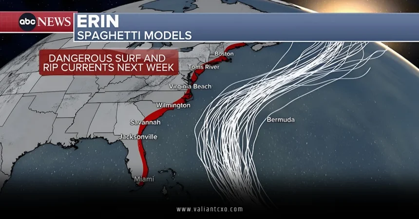
Current Trajectory and Forecast Models
By August 16, the Storm Erin path began to shift. Meteorologists noted a west-northwestward turn, with the storm passing about 150 miles northeast of San Juan, Puerto Rico. Forecast models, often called “spaghetti models” because they look like a plate of tangled noodles, showed Erin curving north by August 18. This northward turn is crucial—it suggests Erin will likely stay east of the Bahamas and avoid a direct hit on the U.S. East Coast. Instead, it’s expected to pass between Bermuda and the U.S., potentially impacting Bermuda by August 20.
But here’s the catch: hurricane paths are as unpredictable as a cat chasing a laser pointer. A high-pressure ridge and a diving trough are wrestling for control of Erin’s trajectory, creating some uncertainty. While most models agree on the northward curve, a slight shift west could bring greater impacts to coastal areas like North Carolina’s Outer Banks.
Impacts of Storm Erin Path on Affected Regions
Caribbean Islands: Heavy Rain and Rough Seas
Even though the Storm Erin path has kept its core away from land, its outer bands have already lashed the Caribbean. Puerto Rico and the U.S. Virgin Islands saw 1-2 inches of rain, with some areas in the British Virgin Islands getting even more. Downed trees and power poles were reported near San Juan, and tropical storm watches remain in effect for the Turks and Caicos. The National Hurricane Center warned of flash flooding, landslides, and mudslides in these regions, urging residents to stay vigilant.
U.S. East Coast: Rip Currents and Coastal Erosion
The Storm Erin path may not bring the hurricane’s eye to the U.S., but don’t let that fool you into thinking it’s smooth sailing. From August 20 to August 27, the East Coast—from Florida to the mid-Atlantic—faces a high risk of dangerous rip currents and large waves. Picture waves as tall as a two-story house, crashing onto beaches and pulling swimmers out to sea like a hidden undertow. North Carolina’s Outer Banks could see waves of 8-12 feet, while South Carolina and Virginia might face 6-foot swells. Coastal erosion is also a concern, especially in areas already battered by previous storms.
Bermuda: A Potential Close Call
As Storm Erin’s path curves north, Bermuda is in the crosshairs. By mid-week, Erin is expected to pass near the island as a Category 2 or 3 hurricane. While it may weaken over cooler waters, its expanded size—potentially doubling or tripling—means Bermuda could face strong winds, heavy rain, and dangerous surf. Residents are preparing shelters and monitoring updates, knowing that hurricanes can be as fickle as a summer breeze.
Why Is the Storm Erin Path So Hard to Predict?
Hurricanes are like chess players making moves on a board influenced by countless variables. The Storm Erin path is shaped by factors like ocean temperatures, wind shear, and atmospheric patterns. Warm waters act like rocket fuel, while wind shear can tear a storm apart. Right now, Erin is thriving in a low-shear environment, but as it moves north, cooler waters and a cold front pushing off the U.S. coast could weaken it. Still, long-range forecasts (5-10 days out) are tricky, with potential errors as wide as a football field. That’s why meteorologists rely on tools like the National Hurricane Center’s forecast cone and spaghetti models to give us the best possible picture.
How to Prepare for Storm Erin Path Impacts
Stay Informed with Reliable Sources
Knowledge is your best defense against a storm like Erin. Keep an eye on updates from trusted sources like the National Hurricane Center for the latest on the Storm Erin path. Their interactive maps, such as the Seven-Day Graphical Tropical Weather Outlook, are updated regularly and show the storm’s projected trajectory. Local news outlets and weather apps can also provide real-time alerts tailored to your area.
Build a Hurricane Supply Kit
Even if the Storm Erin path stays offshore, coastal impacts like rip currents and power outages are possible. Now’s the time to stock up on essentials: non-perishable food, water (one gallon per person per day for at least three days), batteries, flashlights, and a first-aid kit. Florida residents can take advantage of tax-free hurricane supplies, including generators and batteries, as noted by NOAA. Think of it as packing for a camping trip you hope you’ll never take.
Plan for Safety at the Beach
With the Storm Erin path driving dangerous surf along the East Coast, beachgoers need to be cautious. Rip currents are like invisible rivers in the ocean—deceptively strong and deadly. Over 50 people have died in rip currents across the U.S. this year alone. If you’re caught in one, don’t fight it head-on; swim parallel to the shore until you’re free, then head back to land. Check local beach flags and heed warnings from lifeguards.
Strengthen Your Home
If you live in a coastal area, fortify your home against potential impacts. Trim trees to prevent branches from becoming projectiles, install storm shutters, and seal wall openings. It’s like battening down the hatches before a pirate ship sails through. For long-term preparation, consider flood insurance, which takes 30 days to activate, as advised by the Federal Emergency Management Agency.
The Science Behind Storm Erin’s Rapid Intensification
Why did Storm Erin go from a tropical storm to a Category 5 beast in just a day? It’s all about the perfect storm—pun intended. Warm ocean waters, low wind shear, and a moist atmosphere created a Goldilocks zone for Erin to explode in strength. Scientists link this rapid intensification to climate change, which is warming oceans and packing the atmosphere with more water vapor. It’s like giving a hurricane a double espresso shot—it revs up fast and hits hard. Erin’s wind speed jumped 60 mph in nine hours, a rare feat for an August storm.
What’s Next for Storm Erin Path?
As of August 18, 2025, the Storm Erin path is expected to continue its northwestward trek, turning north by Monday. It’s likely to remain a major hurricane through at least Wednesday, August 20, before weakening over cooler waters. Bermuda remains the most at-risk area for direct impacts, while the U.S. East Coast should prepare for indirect effects like rip currents and coastal erosion. But with hurricanes, certainty is as elusive as a shadow in a storm. Keep monitoring updates, as a westward shift could change the game.
Historical Context: How Does Storm Erin Compare?
Erin isn’t the first hurricane to make waves in August. Only four other Atlantic hurricanes have reached Category 5 status this early in the season, including Hurricane Wilma in 2005, which rocketed from a tropical storm to Category 5 in less than 24 hours. Erin’s rapid intensification puts it in elite company, but its path—staying mostly offshore—sets it apart from landfall-heavy storms like Wilma. Still, its size and strength make it a formidable player in the 2025 hurricane season, which NOAA predicts will be above-average with 5-9 hurricanes, 2-5 of them major.
Community Response to Storm Erin Path
In Puerto Rico, residents and tourists carried on with daily life, though some ignored beach warnings, wading into coastal waters despite the risks. The U.S. government deployed over 200 FEMA employees to the island as a precaution, and 367 shelters were prepped. In the Bahamas, officials opened public shelters, urging residents to stay informed. It’s a reminder that even if the Storm Erin path avoids direct landfall, preparation is key. Communities are coming together, proving that resilience is as strong as the storm itself.
Conclusion: Stay Vigilant as Storm Erin Path Unfolds
The Storm Erin path is a reminder of nature’s power and unpredictability. From its rapid intensification to its projected northward turn, Erin has kept us guessing while posing serious risks to the Caribbean, Bermuda, and the U.S. East Coast. While it’s unlikely to make direct landfall in the U.S., its impacts—rip currents, coastal erosion, and heavy rain—demand respect. Stay informed, prepare your hurricane kit, and avoid risky activities like swimming in rough seas. By keeping a close eye on the Storm Erin path, you’re not just staying safe—you’re staying one step ahead of the storm.
FAQs About Storm Erin Path
1. Where is the Storm Erin path headed as of August 18, 2025?
The Storm Erin path is currently moving west-northwest, expected to turn north by August 18. It’s likely to pass between Bermuda and the U.S. East Coast, potentially impacting Bermuda by August 20.
2. Will the Storm Erin path affect the U.S. East Coast directly?
While the Storm Erin path is not expected to make landfall in the U.S., it will bring dangerous rip currents and large waves to the East Coast from August 20 to August 27, particularly affecting areas like North Carolina’s Outer Banks.
3. How strong is Storm Erin, and will it stay that way?
Storm Erin reached Category 5 status with 160 mph winds but weakened to a Category 4 by August 16. It’s expected to remain a major hurricane until at least August 20, though cooler waters may weaken it as it moves north.
4. How can I track the Storm Erin path in real-time?
You can track the Storm Erin path using interactive maps from the National Hurricane Center’s website or local weather apps. Their Seven-Day Graphical Tropical Weather Outlook provides regular updates on the storm’s trajectory.
5. What should I do to prepare for impacts from the Storm Erin path?
Stock up on a hurricane supply kit with food, water, and batteries. Avoid swimming in coastal waters due to rip currents, and monitor updates from reliable sources like NOAA or the National Hurricane Center.
Read More:valiantcxo.com