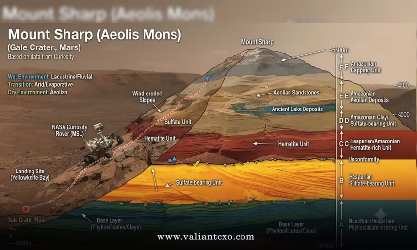
Mount Sharp geology layers form the backbone of what Curiosity has been reading for fourteen years—a vertical stack of sedimentary rocks that records how Gale Crater went from lakes and rivers to the dry landscape we see today.
Quick overview:
- Mount Sharp (officially Aeolis Mons) rises 5.5 km above the floor of Gale Crater and is almost entirely sedimentary.
- Lower layers are clay-rich and lacustrine; higher layers shift into sulfate-dominated rocks.
- Curiosity has climbed more than 1,000 meters by late 2026, moving from the Murray formation through the clay-sulfate transition and into the layered sulfate unit.
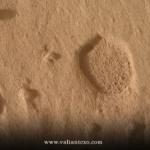
- Recent finds, including the Curiosity rover odd footprints on Mars, sit inside those higher sulfate beds.
- The sequence is not a simple drying curve—new data show intervals of rising groundwater even high in the stack.
That climb is the mission’s core science plan. Each new elevation is a new chapter in the rock record.
How Mount Sharp Geology Layers Are Built
Start at the bottom. The oldest rocks Curiosity examined belong to the Bradbury group on the crater floor—fluvio-deltaic sandstones and conglomerates. Once the rover reached the base of the mound it entered the Mount Sharp group.
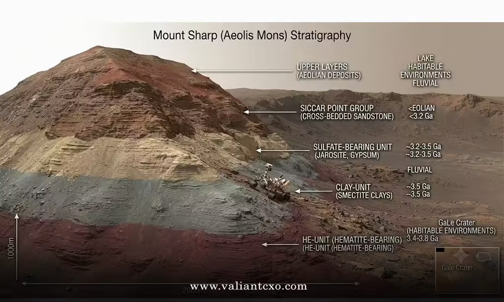
The Murray formation comes first: finely laminated mudstones deposited in a long-lived lake. Clay minerals dominate. Above that sits the Carolyn Shoemaker formation, still clay-bearing but recording a shift toward marginal lake and fluvial conditions. Then the Mirador formation marks the transition zone where clay signatures fade and magnesium sulfates begin to appear in force.
Higher still lies the layered sulfate unit, the package Curiosity is working through now. These beds show more aeolian influence, nodular textures, and rapid changes in resistance to erosion. Boxwork ridges formed by groundwater mineralization appear here. So do the broad, shallow pits that looked, at first glance, like the Curiosity rover odd footprints on Mars.
The entire Mount Sharp group is relatively flat-lying. That means the rover’s upward path is essentially a time machine. Gain elevation and you move forward through depositional history.
Why the Clay-to-Sulfate Shift Matters
Orbiters first spotted the change years ago. Spectral data showed clay minerals giving way to hydrated sulfates higher on the mound. The classic interpretation was progressive aridification during the Hesperian: wetter conditions that favored clays dried out, and sulfates formed instead.
Ground truth has complicated the picture. In the transition zone and the lower layered sulfate unit, Curiosity found evidence of rising water tables, persistent subsurface moisture, and even local fluvial or deltaic deposits at elevations once thought too high for them. The story is not a one-way march toward dryness. There were pauses, reversals, and pockets where water lingered.
That complexity is why the higher layers still surprise the team. Texture, chemistry, and erosional resistance can shift over just a few meters of vertical section. Gray, rough, resistant beds sit next to softer material. Float rocks of different composition scatter across the surface. And in one stretch of Valle Grande, those unexplained shallow pits appeared.
Step-by-Step: How to Read Mount Sharp Geology Layers Yourself
You can follow the same logic the science team uses without specialized software.
- Note the elevation. NASA publishes the rover’s current height above the landing site. Cross-reference it with published stratigraphic columns.
- Identify the formation. Lower elevations = Murray or Carolyn Shoemaker (clays). Higher = Mirador and layered sulfate unit.
- Check mineralogy reports. Clay minerals drop off; Mg-sulfates and, in places, siderite increase.
- Look at texture. Laminated mudstones give way to nodular beds, cross-stratified sandstones, and resistant ridges.
- Watch for anomalies. Features that don’t match the expected process—like the recent pits—flag places where the depositional or diagenetic story needs refining.
Do this for successive mission blogs and the big picture snaps into focus fast.
Common Mistakes When Interpreting Mount Sharp Geology Layers
People oversimplify. Here’s what trips most of us up and how to correct it.
Mistake: Treating the clay-sulfate transition as a single sharp boundary.
Fix: It is a zone. Rover data show mixed signals and overlapping processes across tens to hundreds of meters.
Mistake: Assuming higher always equals drier.
Fix: Recent work in the layered sulfate unit documents intervals of rising water tables and local wet environments. Check the actual depositional structures, not just the mineral names.
Mistake: Ignoring lateral variability.
Fix: The same stratigraphic level can look different a kilometer away. Buttes and valleys expose different faces of the same package.
Mistake: Jumping from “odd feature” straight to exotic explanations.
Fix: Start with differential erosion, diagenesis, and the known mineral suite. The Curiosity rover odd footprints on Mars sit in sulfate beds; the first questions are about weathering and chemistry, not biology.
In practice, the teams that stay closest to the measured sections and instrument data produce the cleanest interpretations.
What the Higher Layers Are Revealing in 2026
By the time Curiosity passed the 1,000-meter mark, it was deep into sulfate-rich terrain. Rapid changes in successive rock beds became the norm. Resistant gray layers, scattered float rocks, and those broad shallow pits all appeared in the same general elevation range.
The pits themselves remain unexplained. They are wider and shallower than typical nodule voids, lack nearby residual objects, and show internal chemistry that differs from the host bedrock. Whatever process made them operated in the sulfate unit. Solving that small puzzle will tighten understanding of how these particular beds weathered.
Meanwhile, the larger context keeps expanding. Clinoform geometries, possible point-bar deposits, and boxwork patterns all suggest that water—groundwater especially—played a bigger role higher on the mound than early orbital models predicted.
| Stratigraphic Package | Dominant Minerals | Depositional Setting | Key Rover Observations |
|---|---|---|---|
| Murray formation | Clays, some sulfates | Lacustrine | Finely laminated mudstones |
| Carolyn Shoemaker | Clays decreasing | Marginal lake / fluvial | Transition textures |
| Mirador / lower layered sulfate | Mg-sulfates increasing | Aeolian with wet intervals | Nodules, sandsheets, water-table signals |
| Higher layered sulfate unit | Mg-sulfates, local siderite | More arid but with groundwater influence | Boxwork, resistant beds, unexplained pits |
The table shows the broad progression. Details inside each package continue to evolve with every new sol of data.
For the primary mission updates that track elevation and formation names, use the NASA Science Curiosity blog series. Detailed stratigraphic synthesis appears in peer-reviewed work such as the Journal of Geophysical Research: Planets papers on the clay-sulfate transition. Orbital context and unit definitions are summarized on the JPL Mars Science Laboratory site.
Key Takeaways
- Mount Sharp geology layers form a continuous sedimentary record more than 5 km thick.
- The lower Mount Sharp group is clay-dominated and lacustrine; higher units shift toward sulfates.
- Curiosity’s 1,000-meter climb has carried it through the clay-sulfate transition and into the layered sulfate unit.
- The transition is not purely aridification—rising water tables and local wet deposits appear higher than expected.
- Unexplained features such as the Curiosity rover odd footprints on Mars occur inside the sulfate-rich beds.
- Texture, chemistry, and erosional resistance can change over short vertical distances.
- Following elevation, formation names, and instrument results keeps interpretation grounded.
- Future sols higher on the mound will test whether the recent wet-interval signals continue or fade.
The next useful step is to track the rover’s elevation and the formation names in the official blogs. That single habit turns scattered image releases into a coherent story of how Mount Sharp was built—and how it dried.
FAQs
What are the main Mount Sharp geology layers Curiosity has studied?
The Mount Sharp group includes the Murray formation (clays, lake deposits), Carolyn Shoemaker formation (transition), and the Mirador formation plus layered sulfate unit (increasing Mg-sulfates and aeolian influence).
Why do Mount Sharp geology layers matter for the Curiosity rover odd footprints on Mars?
Those pits sit inside the higher sulfate-rich beds. Understanding the host rock’s mineralogy and weathering history is the first step toward explaining the pits themselves.
Is the clay-to-sulfate change a clean drying trend?
No. Rover data show intervals of rising groundwater and local wet deposition even within the sulfate unit, complicating the simple aridification model.