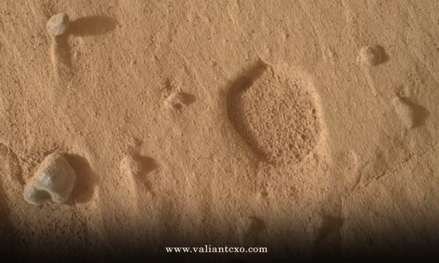
Curiosity rover odd footprints on Mars grabbed headlines in September 2026 when NASA’s long-running explorer snapped images of broad, shallow pits that looked, at a glance, like something had walked across the bedrock.
Here’s the quick rundown for anyone skimming:
- These are not actual footprints or animal tracks—just unusual pits roughly 1 cm across.
- Found while Curiosity climbed Valle Grande on Mount Sharp inside Gale Crater.
- Unlike typical Martian pits left by weathered-out nodules or pebbles, these lack any leftover objects nearby.
- The team used MAHLI, Mastcam, ChemCam, and APXS to document them; formation process remains unexplained as of mid-September 2026.
- They add another data point to how sulfate-rich layers higher on the mountain weathered differently than lower units.
The discovery landed right after Curiosity hit its 1,000-meter elevation mark. Fourteen years in, the rover still finds new ways to keep the science team guessing.
What Makes These Curiosity Rover Odd Footprints on Mars Different
Most pits on Mars form the way you’d expect. A harder pebble or mineral nodule sits in softer rock. Wind and time wear the soft stuff away first. The hard bit eventually falls out, leaving a neat little hole that matches its shape.
These new ones break that pattern. They’re wider and shallower. No leftover pebbles or nodules sit nearby. The material inside the pits even shows different chemistry from the surrounding bedrock, according to early instrument readings.
Michelle Minitti, deputy principal investigator for the Mars Hand Lens Imager, put it plainly in the official mission update: the features were “unlike quite anything we have seen in the past.” The pits appeared across multiple workspaces during sols 4988–4994.
Think of it like finding a series of shallow, empty footprints in wet concrete after the person who made them walked away—and the concrete dried without any other trace of who stepped there. The shape is clear. The maker is missing.
How the Team Documented the Curiosity Rover Odd Footprints on Mars
Curiosity didn’t just take a snapshot and move on. The science team treated the pits as a genuine puzzle.
MAHLI, the camera on the end of the robotic arm, moved in close for high-resolution composites. Mastcam captured stereo mosaics so researchers could build digital elevation models and measure exact depths and shapes. ChemCam lasered the surrounding rock and the pit material itself. APXS checked elemental composition.
The goal was straightforward: gather every possible clue before the rover rolls farther up the mountain. Data analysis takes time. As of the latest public updates, no firm formation mechanism has been locked in.
Location matters. Curiosity is working through sulfate-rich layers higher on Mount Sharp. These rocks record a different chapter of Martian history than the clay-bearing units lower down. Changes in texture and chemistry appear over short vertical distances. The pits sit right in the middle of that transition zone.
Step-by-Step: How Beginners Can Follow New Curiosity Discoveries
You don’t need a PhD to track what the rover finds. Here’s a practical way to stay current without drowning in raw data.
- Bookmark the official NASA Science Curiosity mission updates page. New blog posts appear every few sols when the team plans science.
- Check the raw image gallery on the Mars Exploration Program site. Search by sol number or camera (MAHLI or Mastcam) for the latest close-ups.
- Follow the JPL and NASA social channels for quick image releases and short explanations.
- Cross-reference with reputable space news outlets that quote the mission scientists directly rather than adding speculation.
- When a new feature appears, note the sol number, location (for example, Valle Grande), and which instruments examined it. That context keeps the story grounded.
Do that consistently and you’ll spot the difference between a genuine new puzzle and the usual internet noise.
Common Mistakes & How to Fix Them When Interpreting Mars Images
People jump to conclusions fast. Here’s what usually goes wrong and how to course-correct.
Mistake: Assuming any linear or repeating pattern equals biological tracks.
Fix: Check the scale. A 1-centimeter pit is not a footprint. Look for matching objects or tool marks from the rover itself.
Mistake: Ignoring the official mission blog in favor of viral social posts.
Fix: Start with the NASA-authored update. Secondary reporting should quote it, not invent explanations.
Mistake: Treating every odd shape as evidence of past water or life.
Fix: Ask what the instruments actually measured. Chemistry and morphology first. Speculation later.
Mistake: Forgetting that wind, frost, and differential erosion still operate on Mars today.
Fix: Compare the new feature to known processes already documented by Curiosity and earlier rovers.
In my experience watching these missions, the teams that stay closest to the raw data avoid the biggest headaches. The public conversation runs smoother when everyone works from the same primary sources.

Why These Pits Matter for Understanding Mount Sharp
Curiosity’s climb is a vertical trip through time. Lower layers show evidence of ancient lakes and rivers. Higher sulfate layers record drier conditions and different mineral chemistry. The odd pits sit in a zone where depositional environments appear to have shifted quickly.
If the pits formed through an erosion process not previously observed, that process could explain other textures higher up the mountain. If they reflect something unique about the rock itself—perhaps a particular mineral that dissolved or weathered in place—then the chemistry data already collected becomes even more valuable.
Either way, the features force the team to refine models of how these specific beds broke down. That’s the real payoff. Every unexplained detail eventually tightens the larger story of how Gale Crater dried out.
| Feature Type | Typical Size | Usual Cause | Key Difference in 2026 Pits |
|---|---|---|---|
| Standard nodule pits | Millimeters, deeper | Weathered-out pebbles or hard nodules | Matching objects usually found nearby |
| Impact micro-craters | Variable | Small meteorites | Often show raised rims or ejecta |
| 2026 broad shallow pits | ~1 cm across, shallow | Unknown | No leftover objects; different internal chemistry |
| Boxwork ridges | Meters long, low height | Groundwater mineral deposition | Resistant ridges, not pits |
The table above puts the new pits in context against features Curiosity has already mapped. Nothing matches exactly.
For the official description straight from the instrument team, see the NASA Science Curiosity blog post covering sols 4988–4994. Detailed reporting on the same findings appears at Space.com’s coverage of the September 2026 images. Background on how Curiosity documents surface features lives on the JPL Mars Science Laboratory page.
Key Takeaways
- The Curiosity rover odd footprints on Mars are broad, shallow pits discovered in August 2026 on Mount Sharp.
- They differ from standard weathering pits because no residual nodules or pebbles remain nearby.
- Multiple instruments collected close-up images, stereo data, and chemistry measurements.
- The formation mechanism is still under study; no biological explanation is supported by the evidence.
- The pits sit in sulfate-rich layers that record a shift in Martian environmental conditions.
- Following primary NASA mission updates remains the most reliable way to track ongoing analysis.
- Similar-looking features on Mars have repeatedly turned out to be geological once scale and context are considered.
- Curiosity continues climbing; future sols may provide comparison sites that help solve the puzzle.
Keep an eye on the next few mission blogs. The team will release more detailed measurements once the data products are fully processed. That’s the cleanest next step if you want the real answer instead of the speculation that always follows an unexplained Martian surface feature.
FAQs
Are the Curiosity rover odd footprints on Mars evidence of past life?
No. The pits match no known biological process at this scale, and the mission team has described them strictly as geological features requiring further study.
How big are the Curiosity rover odd footprints on Mars?
The example imaged by MAHLI measures about 1 centimeter across and is notably shallow compared with earlier pits the rover has documented.
Will Curiosity investigate similar features higher on Mount Sharp?
Yes. As the rover continues its climb through the sulfate layers, the team will compare any new pits against the 2026 set to test formation hypotheses.